Yesterday, the European Union’s Copernicus Climate Change Service announced that July 2019 was the warmest month on record, continuing the long period of unsustainable global heating to which we are subjecting our planet. The statistics are stark – last month was 1.01 C warmer than the average July temperature between 1981 and 2010. The previous record was set in July 2016. The odds are strongly in favour of the new record being broken within the next few years.
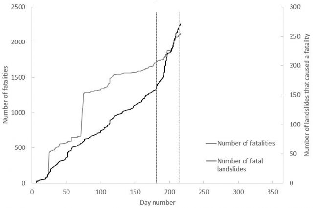
In 2019 I recorded a total of exactly 100 fatal landslides, breaking the previous record by a considerable margin. These landslides killed 358 people. By comparison, in 2018 I recorded just 51 fatal landslides, causing 148 fatalities. The graph below shows the cumulative total of fatal landslides, and the resulting deaths, for the year to date (correct as to 5th August 2019), but note that this data has not been subjected to the validation process that will allow it to be included in the main dataset as yet):-
The cumulative graph for fatal landslides, and the resulting fatalities, in 2019 to date.
.
The black line is the number of landslides that I have recorded worldwide that have led to the loss of at least one life, whilst the grey line is the cumulative total of the number of resulting fatalities. The dashed lines indicate the start and end of July. The rapid acceleration in the number of fatal landslides at the start of the month is clear. This reflects the onset of the South Asian monsoon and is the normal pattern. However, the number of landslides recorded in unprecedented. In this period, there have been many landslides in South Asia (most notably Nepal, India and Bangladesh), but I have also recorded events in, for example, UK, Norway, USA, Myanmar, Tajikistan, Thailand, Guinea, Switzerland, Brazil, China and elsewhere.
At this stage it is not clear as to the cause of this surprising number of fatal landslides. It has long been suggested that increased global temperatures will lead to higher rainfall intensities (put simply, a warmer atmosphere can hold more moisture), and there is strong evidence that this is occurring. Most of the landslides in July 2019 were triggered by short duration, high intensity rainstorms. Whilst a single month does not prove the link by any means, July 2019 serves to illustrate once again the challenges that we will face in the future.
A Nelson couple say they feel bullied and stressed after National MP Judith Collins filed a lawsuit over a landslip that happened almost eight years ago.
Collins and her husband David Wong-Tung are suing the Nelson City Council along with Ashley Cooper and Ingrid Penfold, seeking $180,000 for remedial works and lost rental income, plus other costs, after the slip in the 2011 Nelson floods damaged their property.
Collins and Wong-Tung own a heritage-listed 1880s cottage in Nelson’s Haven Rd that sits below the Queens Rd property owned by Cooper and Penfold’s company.
In a statement of claim to the Nelson High Court, Collins and Wong-Tung say the slip in December 2011 saw the house declared unable to be occupied without remedial work.
The pair got a $39,500 Earthquake Commission payout but say it was not enough to reinstate the land. They estimate another $110,0000 is needed to repair the property and in the meantime they have lost $67,000 in rental income.
MARION VAN DIJKThe slip in 2011 followed a major deluge across Nelson. Judith Collins and David Wong-Tung’s property is the white cottage on the left.
Cooper and Penfold say they remediated their land following the slip with the work signed off by council. They were shocked to learn they were facing civil action in December 2017, almost six years after the incident.
“We were handed a summons saying they were suing us for damage to their land and loss of income, we had no idea there was an issue, as far as we were aware everything was remedied and it just came completely out of the blue,” Cooper said.
“The stress has been unbelievable.”
Collins was the Minister of Justice when the slip occurred and Cooper wondered if she had waited until National were no longer in Government before taking legal action.
“When we found out who it was that was suing us it made us even more worried because obviously the connections, the money these people have got and the power and the influence.”
Cooper had a stress disorder which he suffered from prior to the slip but had since been hospitalised twice for.
“It’s really badly damaged us, emotionally, financially, we just don’t have the money to go up against these sorts of people.”
Cooper said since the slip he had not once been approached by Collins or Wong-Tung. It also appeared they had done no structural work on their land to stop further slips from occurring.
“They are saying they are concerned about future slips and stuff not being done correctly but they waited six years to even try to remedy the problem.
“We personally don’t think we have done anything wrong, everything was signed off by the council and the engineers.”
JOE LLOYDThe Haven Rd property owned by Judith Collins and David Wong-Tung.
Cooper and Penfold bought their Stepneyville home which overlooks Port Nelson in May 2011.
They were aware there were outstanding issues with the property. An Earthquake Commission payment had been made to the previous owners for work needed to stabilise the land, except it hadn’t been done.
“We were aware of that, it wasn’t hidden from us. So when we bought there was work that had to be carried out for us to insure the property, and we were actively trying to get the work done as soon as possible,” Cooper said.
They applied for building consent to make alterations to the property in July 2011, including the removal of a sun room and the installation of a deck. Before granting consent, the Nelson City Council requested a geotechnical report be undertaken.
The report which came back in August noted that ineffective stormwater control and a yard sump were likely to have exacerbated movement on the slope below and that the landslide risk on the property was currently high.
JOE LLOYDAshley Cooper and Ingrid Penfold discuss the legal battles over a slip that happened on their Queens Rd property in 2011.
Cooper said they had been unable to start work until they had the building consent, but in order for that to be granted they had to wait for geotechnical and engineers reports.
Cooper who himself is a builder, said they were about six weeks into the work when heavy rain that began on December 14 caused widespread flooding and significant damage across the region, prompting a state of emergency.
During the deluge, a major slip occurred on the land above Haven Rd. As the rain continued, the slip got closer and closer to Cooper and Penfold’s property, ending up about a metre from their house and taking away two of the retaining piles from the new deck.
Information from NIWA showed 160 houses were evacuated in Nelson due to flooding or landslides, there were more than 200 slips in the wider region and insurance claims from the event totalled $16.8 million.
The flooding in Nelson was described as a one in 250 year event, with 329 millimetres of rain falling at The Brook and 205 mm at Richmond over a 24-hour period.
DON SCOTTThe one-in-250-year storm in 2011 caused slips at a number of properties on Haven Rd.
The couple said they had since undertaken the work needed to remediate the site, which included installing a large retaining wall as directed by council and engineers.
“When the slip happened we had to put in a retaining wall and stabilise the house and we had to fund that ourselves, we had no EQC payout or insurance cover,” Penfold said.
The ordeal had left them feeling intimidated and bullied and had been “financially crippling”.
It had been a case of “scrimping and saving” to make ends meet. They estimated they had spent more than $50,000 on the repairs, not including the time spent by Cooper and others working on the property.
Cooper said the contractors had been very supportive and had agreed to wait until the couple had the funds to make payment.
Now, they were spending thousands of dollars a month on legal bills.
“If it goes to the High Court we are talking six digits, we have been warned about that. So where does that leave us?” Penfold said.
Cooper said he hoped the matter could be resolved at mediation, scheduled for next week.
Nelson City Council acting group manager environmental management Matt Heale said there was little it could say given the matter was before the courts but confirmed council would be defending the charges.
He said the Haven Road property was issued with a notice under the building act preventing it from being reoccupied on December 23, 2011. That notice had not yet been lifted.
Collins had not responded to requests for comment.
If an agreement couldn’t be reached in mediation, the case would be heard in the High Court.
More than six years after Hawke’s Bay’s only marine reserve was inundated by landslides, birdlife is returning to the sanctuary, with the help of unmanned aerial vehicles.
The cliffs at Te Angiangi Marine Reserve have been bare since a bad storm in April 2011 when 550mm rainfall and a 4.6 earthquake caused them to collapse.
At the time it was feared the landslips could have altered the landscape of the marine reserve forever.
However, DoC Hawke’s Bay biodiversity coastal marine compliance ranger Rod Hansen said the reserve was “looking in pretty good shape”.
“There’s still a lot of fill washing from the slips into it but I think it has recovered quite well. There was a lot of work done immediately the year after the slip obviously in terms of replanting and re-vegetating the coast.
“So it has been really good. We have an area taped off to the north of the reserve where the New Zealand dotterels are. We have quite a high birdlife living in there at the moment, and it’s quite noticeable that the dotterels are now at both Aramoana and Blackhead, so things are looking pretty good.”
The initial work was mostly carried out by machine, taking up logs as fill. The slopes were then re-grassed and 3000 native plants planted.
Ongoing restoration work had been a combined effort from Department of Conservation working with the Aramoana Environmental and Education Charitable Trust and local iwi Ngati Kere.
In the past season, seeds had also been dropped over the hillside with the use of drones.
“We picked flax seed, then flew up on the faces and dropped the seed on the faces. You can see the results of that now, with flax started to grow on the sides.”
It was now planned to fly cabbage tree seeds up there, later this year, he said.
“We don’t know what sediment levels are out there at the moment but we will be doing some monitoring in there shortly.”
Te Angangi Marine Reserve, 30km east of Waipawa, was established in August 1997 and is managed by DoC.
It is the only marine reserve in Hawke’s Bay and covers an area of about 1.3 square nautical miles (446 hectares), extending 1 nautical mile offshore from the mean high water mark between Blackhead and Aramoana beaches.
The reserve protects a typical piece of Hawke’s Bay coast. At low tide a board rock platform is exposed, giving access to a fascinating variety of marine life, comprising a mix of fauna and flora including crayfish, paua, reef fish such as moki, butterfish, cod and sea coral
Two major slips near the main shopping strip in Birkenhead are raising alarm bells about the stability of the area and public safety.
Northcote MP Jonathan Coleman says there is a risk of buildings keeling over and is seeking assurances from Auckland Council there will not be “some sort of serious catastrophic movement”.
He was commenting after a second slip on Tuesday this week swallowed a digger, sent a concrete light pole sliding more than 100m down into Rawene Reserve and workers scattering.
The first slip in October took about 50m of car park land, 25 carparks and huge volumes of soil mixed with tarmac, drains and stormwater debris.
Coleman today said he wants investigations being carried out by Auckland Transport extended to a carpark on the other side of the main shopping strip where “there now seems to be some movement in the ground”.
A local optometrist, Tony Chadwick, said the movement had got worse recently.
An inspection of the carpark found two areas showing movement. In one area, the ground across the cracking has subsided about 50mm.
Chadwick, whose business backs onto the slip and is now just 20m away from the latest slip, said he had received assurances from Auckland Transport that there is no danger but wanted to see the evidence.
“We are concerned our buildings are in danger. What we need is evidence that they are not. We are not getting the evidence,” he said.
Chadwick is also concerned that AT are making retrieving a lost digger a priority and work is proceeding on a main street upgrade in Birkenhead when the priority should be fixing the slip.
“You have got a sinking ship. You are painting one side while the other side is going down. It’s madness,” Chadwick said.
Coleman said it was known there was loose fill around the Rawene car park slip area but he had been told anecdotally about stormwater issues at the second car park, raising wider issues about stability of the land around Mokoia Rd from the car park through to the slip.
He said he spoke with Auckland Mayor Phil Goff about the “serious situation” yesterday and has sought assurances from the highest levels of council about public safety and the safety of buildings.
Goff could not be reached for comment today.
AT chief engineer Andrew Scoggins said a range of reports are being developed by expert advisers and these will be shared with the community at a meeting in the coming week.
“AT’s design consultant will use this data to design stabilisation works,” he said.
Scoggins said he was not aware of the cracks in the other car park, but they would be looked at as part of its investigation.
AT plan to close the Rawene carpark next week for salvage cranes and equipment to remove equipment which went down the slip last week.
Kaipatiki Local Board chairwoman Danielle Grant said the priority was the health and safety of the community, but added the slip was having a big impact on local businesses in the lead-up to Christmas.
She said the timing for a $2 million upgrade of the main street, due to start in February, should be reconsidered.
Research into why Omokoroa cliffs are prone to slips is getting a financial boost.
The Western Bay of Plenty District Council will contribute funds over the next three years towards Omokoroa landslide research, with University of Waikato Doctoral students believing they might have found a way to stabilise the sensitive soils and reduce the number of landslides.
The Council will contribute $10,000 annually over the next three years towards a University of Waikato Doctoral Research Project on Omokoroa’s geology, centred on soil stabilisation.
Dr Moon and her colleague Dr Willem de Lange, presented an update of their research to Council’s operations committee this week.
The team has been studying Omokoroa’s landslides since 2009, focusing on the Bramley Drive landslide that occurred in 1979.
Dr Moon said their attention was on the failure of the sensitive soils at the base of landslides.
Dr Moon said initial laboratory testing showed huge promise with a big uptake of the salt and a near-doubling of the peak strength of the soil. However, more testing is required over a wide range of stresses to confirm the early results.
A small field trial in Omokoroa will be carried out when possible to install soil-mixed columns and monitor how quickly concentrations of the salt can be achieved.
On-site research has been stalled since Cyclone Debbie caused further slippages in April this year, making the cliff sites unsafe for researchers.
Omokoroa has two types of landslides
Translational and flow slides – the most damaging are the flow slides due to the fragility of the sensitive soils. These soils are mainly made up of halloysite – a mineral that forms in old volcanic ashes typical to Omokoroa.
The latest findings of the research project indicate a form of salt can act as a stabiliser in halloysite-rich soils by ‘locking up’ the soils over a period of time.
The project, led by Earth Sciences senior lecturer Dr Vicki Moon and undertaken by doctoral student Tom Robertson, is focused on discovering how to improve the stability of the material in the sensitive soils that make Omokoroa’s peninsula cliffs prone to slippage.
A neighbour of the Eastern Beach home left sitting precariously on the edge of a collapsed cliff says she is disappointed with Auckland Council’s lack of concern for homeowners of Clovelly Road’s cliff top houses.
This follows a massive landslip in which a 10-metre high cliff face collapsed claiming half of a Clovelly Road home’s backyard on Sunday.
A slab of the deck has been left hanging over the cliff and occupants of the neighbouring properties have been warned off going too close to the edge.
The slip was filmed by Bucklands Beach resident Ben Dellabarca who says his dogs were underneath the cliff just moments before it collapsed onto Eastern Beach.
The concerned neighbour, who declined to be named, says these slips are devastating for home owners, and the process of making a claim with the Earthquake Commission (EQC) – who deal with these sorts of problems – can take months.
“One of our other neighbours had a slip at Easter time and he is still trying to deal with EQC… council don’t seem to care all that much if the cliff collapses, because it’s not their problem, its EQC’s problem,” she says.
“Further down the road, a house was condemned just a few weeks ago after another slip.”
The Clovelly Road resident says taking precautions to protect her home from the same fate proved a lengthy and drawn-out process.
She says it took more than two years to have a retaining wall signed off by council that would protect her home from landslips. The wall was signed off just weeks before Sunday’s slip.
“When we bought this house we were told by the geotech engineers who surveyed the property that the land we were on could be unstable,” she says.
“We decided to put the wall in, but it just got held up by council. They made us bend over backwards to get it done and it’s only just been completed now.”
She says she is glad to finally have it completed, fearing for the safety of her home and her family.
Auckland Council geotechnical engineer Ross Roberts says houses built on cliff tops face unique risks and Clovelly Road has a history of instability.
“The council has today investigated the slip and its impact on the buildings directly at the top of the cliff face. We have also ensured the area below the slip is made safe for the public, including putting up signage,” Roberts said on Monday.
“Neither the property filmed by a member of the public nor two neighbouring properties are considered dangerous.”
He says unless there is further movement that directly affects any buildings, this is a private matter and will be dealt with by individual owners and EQC.
Former Local Board member and Clovelly Road resident Steve Udy says people need to understand the dangers of chasing a beautiful view.
“There are a section of houses along Clovelly Road which are built in what I think is just a shade too close to the cliff. When they build those, they must understand Auckland’s coastline is fairly crumbly and there are risks,” he says.
Udy says there needs to be a sensible look at how many houses the Eastern Beach coastline can sustain and people need to be cautious when extending their properties towards the cliffs edge.
There needs to be clearer distance guidelines from Auckland Council, Udy says, to ensure property owners are building a safe distance from the edge of the cliff.
The Clovelly Road property of former Manukau City mayor Sir Barry Curtis succumbed to a cliff collapse in 2008.
“We need to be very sensible, the council, property developers, owners, everyone, and look at how much intensity can a fragile area like this stand,” says Udy.
“I think Mother Nature is saying this is too much.”
Moments after Ben Dellabarca’s two dogs had passed beneath it, a 10-metre cliff collapsed onto Auckland’s Eastern Beach on August 20.
He and his flatmate were walking his dogs long Eastern Beach around midday on Sunday when the pair noticed rocks coming off the rock face.
Suddenly a massive hunk of dirt, debris, trees and what seemed to be a retaining wall fell away, crashing onto the beach below and taking a large chunk of a Clovelly Road home’s backyard with it.
All that was left was a slab of decking hanging precariously over the cliff edge.
A local Pakuranga man, who declined to be named, has told the Eastern Courier that he did the lawnmowing for an adjacent neighbour on Clovelly Road and says he’s amazed the Auckland Council wasn’t alerted earlier.
“I cut the lawn on August 12 and the cliff-side had already started falling to the sea.
“It took a guy posting a vid to social media with a cell phone before it became public knowledge. Luckily no one got killed,” he says.
Tonkin and Taylor representatives were also at the cliff site on Monday on a pre-planned visit to investigate the slips on behalf of the Earthquake Commission (EQC).
Council geotechnical engineer Ross Roberts says the slip happened in an area of known instability.
“Houses built on cliff-tops face unique risks and Clovelly Road has a history of instability. This is not the first time part of the cliff face has eroded.”
He says the council has investigated the slip and its impact on the residential buildings directly at the top of the cliff face.
“We have also ensured the area below the slip is made safe for the public, including putting up signage.
“Neither the property filmed by a member of the public nor two neighbouring properties are considered dangerous,” Roberts says.
All potentially affected occupants and homeowners have been informed of the slip and are working with EQC, he says.
“Unless there is further movement that directly affects any buildings, this is a private matter and will be dealt with by individual owners and EQC.
“The council will continue its approach to managing more than 90 cliff slips on public land across the region.”
A sudden collapse of a 10-metre cliff has swallowed a backyard in East Auckland.
Real estate agent Ben Dellabarca and his flat mate were walking his dogs long Eastern Beach around midday on Sunday when the pair noticed rocks coming off the rock face.
All of a sudden a massive hunk of dirt, debris, trees and what seemed to be a retaining wall fell away, crashing onto the beach below.
“The dogs were under it only a minute before it fell,” Dellabarca said.
A slab of decking survived on the Clovelly Road property, hanging precariously at the top of the cliff with nothing beneath it.
Dellabarca, who captured the moment the cliff collapsed on video, estimated it to be about 10-15 metres tall.
He said he tried contacting the owners of the house above but they weren’t home.
Auckland Council geotechnical engineer Ross Roberts said the slip happened in an area of known instability.
“We will be investigating tomorrow.”
On Monday morning, Auckland councillors for Howick, Sharon Stewart and Dick Quax, first inspected the damage from the beach below the slip, before visiting the property from its Clovelly Road entrance.
On average, there are three deaths a year from landslides in New Zealand and there are more recorded fatalities – 700 deaths – from slips than earthquakes and tsunami, says GNS Science engineering geologist Chris Massey.
“That number of fatalities is higher than earthquakes and tsunami.
“So landslides are a real problem. It’s not just the deaths, the people that they kill, but it’s also the damage to property, the damage to infrastructure.”
GeoNet said there were about 400 slips on artificial slopes on the Wellington City Council road network each year.
Mr Massey said most slips were triggered by rainfall and the main factors influencing the risk of a landslide are geology, climate, and land use.
”The thing is, though, not many people live on slopes… Many in Wellington do, but in the rest of the country a lot of people don’t live on slopes so the risk isn’t evenly distributed across the whole population. It’s kind of weighted to the people who live on slopes.”
Wellington’s built environment has been tested over the decades with high intensity rainfall events, but it has not been tested by a large earthquake generated by the region’s closest faults – the Wellington fault and the Hikurangi subduction zone off the east coast of the North Island.
In hilly Wellington, a lot of the land has been modified to accommodate buildings, roads, and infrastructure.
”These modified slopes, because they’ve only been really constructed since the 1930s, 40s, 50s, and have never actually seen a really strong earthquake… we really don’t know how these slopes will perform under a really strong earthquake. Not like the earthquake we’ve had recently in Wellington but a real strong earthquake, something like a Kaikōura type of earthquake.
”They’ve been tested for rain.
”They haven’t really been tested for strong ground shaking associated with a large earthquake.”
New Zealand is tectonically active and temperate, with high annual rainfall, which means the landscape is dynamic and slip-prone.
The majority of slips are triggered by rain. Geology, climate, and change in land use are the main factors.
Mr Massey said the capital had a history of landslides.
”In the past we’ve had similar landslides under similar rainfall conditions.
”When it rains… it increases the mass of the slope and decreases the effect of stress of the material. By doing that it reduces the strength of the material because the water kind of percolates in through the pores of the material.”
As rainfall intensifies, a slope saturates and essentially liquefies, reducing the material’s strength.
The higher the rainfall intensity, the more landslides happen.
Wellington was built on steep slopes on greywacke. Slip-prone land tended to sit on top of rock defects filled with weaker material or areas where runout was possible, Massey says.
Whether a slope is susceptible to slipping depends on material type, soil or rock, and the angle.
”Those kinds of slopes will not be stable at the same slope angle as other slopes that say didn’t have those defects in them, or the orientations were more favourable for stability.
”It’s a really complicated issue.
”For different types of soil and rock we have different angles that the slopes are comfortable or stable at and you can calculate a probability of a landslide occurring in different combinations of material type and at different slope angles, different rain or earthquake events.”
National Institute of Water and Atmospheric Research marine geologist Dr Josh Mountjoy says many areas sit on greywacke, a weathered, fractured, and porous sandstone.
”The Tararua range and a lot of the mountains in the South Island are all underlain by greywacke.
”It underlies most of the country and all of the hills around Wellington are greywacke material.
”It’s a hugely variable material – the characteristic is it’s just been through a huge amount of tectonic deformation – basically being chopped up by a lot of faults and folded by earthquakes and fractured over a long, long period of time.
”Overall it’s become quite a weak rock mass that is susceptible to failure.”
GeoNet says there have been more than 2000 claims for damage from landslips in Wellington since 1990.
An ancient landslide at Green Lake in Fiordland – thought to be the largest in the world – dumped 27 cubic kilometres of material over 45 square kilometres between 12,000 and 13,000 years ago.
Auckland’s storms and heavy rain have caused more than 100 new slips around the coast, with the council facing a huge task cleaning them up.
Auckland Council can’t say yet what the repair bill will be, because it has to plan the work, a task made more challenging by the fact more landslides are occurring every week.
“Auckland Council has budget set aside each year for minor storm damage. However, the most recent weather events and subsequent slips that have occurred are being treated as major damage, which will include both operational and capital expenditure,” general manager of community facilities Rod Sheridan said.
The council’s principal geotechnical specialist, Ross Roberts, said, in the week just past, about five new slips had appeared.
“We take a risk-based approach. We look at what’s impacted by it [the slip] and what could be impacted if it gets worse,” Roberts said.
Kennedy Park stairs at a World War II site on Auckland’s North Shore were affected by one such slip.
“The high priorities for us are the ones where public access has been severely compromised. The higher the risk, the higher the priority.”
Roberts said the “ease of reinstatement” also played into the prioritisation process, some could be important to fix but also difficult.
The stairs, popular with exercisers, were contorted when the land beneath them slipped during torrential rain in April.
“It’s a challenging site, and one where putting it back exactly where it was is probably not acceptable,” Roberts said. “We don’t want to be doing the same thing in three or four years.”
The Lotus Track, north of Browns Bay, was also a challenge, because clay had fallen away from beneath the path and the path couldn’t be re-aligned closer to the cliff, Roberts said.
He estimated the council was dealing with more than 100 slips across Auckland on public land, with even more on private land. Private slips fell under the control of the Earthquake Commission, he said.
Residents of an Auckland apartment block struck by a landslide this week have been told the cliff behind their homes poses “no imminent risk”.
San Remo Apartments resident Craig Jones received the good news from Auckland Council this afternoon.
He and the occupants of other affected apartments in the suburb of Kohimarama were told they could move back in once their apartments were deemed habitable.
Waist-deep mud poured through several of the building’s 11 apartments when torrential rain pummelled Auckland on Tuesday evening.
Residents of six front apartments were not affected and had already returned home, but those living in five rear apartments have been in limbo.
Jones, 45, was home today removing personal property and said several truckloads of mud had also been dug out of the apartments.
There had been fears residents may have to wait years to return, amid concerns work might need to be done to the cliff, Jones said.
“At least now we won’t be held up, so that’s good news.”
His apartment had been “gutted” and the inside would need to be cleaned, but he hope to move back in this year.
Despite the disruption, he was philosophical.
“We are all alive, so that’s the main thing. You’ve just got to roll your sleeves up and get on with it.”
And three days after the torrent of mud smashed into his home, knocking him from his feet, Jones remained in awe of the emergency services who came to residents’ aid.
“We just want to say thank you for their commitment and professionalism on the night.”
West Auckland homes have been evacuated after a landslide caused fears for residents’ safety.
Three homes in Titirangi’s Grendon Rd were cleared by police on Wednesday morning after a river of mud and trees washed down a hillside.
One elderly resident objected to evacuating his “at-risk” property but had been convinced to leave, police said.
Meanwhile, residents of Landing Rd, further down the hill, were trapped in their homes by the mud.
Tony Matthews said he was woken up at 2am by his neighbour banging on his door.
“He heard a huge crash and half a hillside has come down across the driveway.”
The shared private driveway, in Landing Rd, was blocked and five houses were cut off.
Matthews said the mud slide was about ten metres high.
“It’s mostly just mud with some trees. We’re not sure how long we’ll be stuck here, no one can leave until we’ve cleared it.”
Matthews said there was no damage to houses, and “thankfully” no one was hurt.
His neighbour Felicity Farrell said they were concerned with the rain forecast for later on Wednesday afternoon.
“We can clear the mud and trees but there’s still a lot of water running down the hill,” Farrell said.
Meanwhile, west Auckland resident Richard Miller had a late-night escape to a hotel after the deluge flooded his Waima home.
“The water came in after the rain had stopped at 10pm on Tuesday. It all comes running down off the hills so we packed up the kids and took them somewhere dry,” he said.
It’s the second time his home has been flooded in three weeks.
“I’m a bit concerned what will happen today with more rain coming later.”
Properties around Auckland have been impacted by flooding with more rain forecast for Wednesday afternoon.
Landslides, caused by torrential rain, have swallowed part of the backyards of three clifftop properties on Auckland’s North Shore.
Large mounds of clay, bedrock and pohutukawa trees were visible in the muddy waters of the Torbay coast, after breaking off the cliff about 5am on Wednesday.
Sharon Rd resident Andy Fear said the landslides were so loud, he thought he was hearing a thunderstorm and couldn’t get back to sleep – so he decided to make a start on the day and go into work early.
“A little after 6 o’clock I had a phone call from my wife, she told me that there was no rear garden any more, unfortunately,” Fear said.
“I rushed home from work… and discovered that at least a section of three metres to 25m wide had actually fallen into the ocean, along with the fence and everything else.
SUPPLIED
Fear’s back yard was left fragmented and cracked after a landslide swallowed most of it.
“It was very scary, and a far bigger thing than I envisioned when I got the phone call. The damage come closer to the property than I thought it would.”
The slip left his backyard fragmented, with “big cracks” he was told would eventually break off with future heavy rain and fall into the ocean also.
The Fire Service, police, council and geotechnical engineers visited his and his neighbours’ properties throughout the morning, to asses the damage and risk of further landslides.
ZIZI SPARKS/FAIRFAX NZ
“Truckloads” of cliff have fallen onto the beach below, firefighters say.
“Their conclusion is that I am safe at this moment in time, and if it worsens, to get back in touch with them.”
Auckland Council’s Building Control Manager Weathertightness and Compliance Sally Grey said their structural engineers were satisfied the properties on Sharon Rd could remain occupied, but the situation would continue to be monitored until the rain clears.
She said the stretch of beach below the slips, between Browns Bay and Waiake Bay, would remain closed for safety reasons.
SUPPLIED
The view before the landslide – note the pohutukawa trees.
Fear’s back yard was also out-of-bounds, being cordoned off with police tape – cutting off access to his six free-range chickens in their coop, “Cluckingham Palace”.
“They’re probably feeling quite alone at the moment, [we have] not been allowed to go down there to see them.
“They are fed and watered at the moment, but we will have to make plans soon, I’m sure to go and evacuate them to better accommodation.”
SUPPLIED
The view after the landslide.
The slip may have shaved several metres of the back of his property, but Fear said there was a silver lining, of sorts.
“We are now free of pohutukawa trees that were obviously a feature before – but now we have a great view.”